[ Homepage ] [ Introduction ] [ Warning ] [ Ratings ] [ Ethics ] [ Feedback ] [ Updates ]
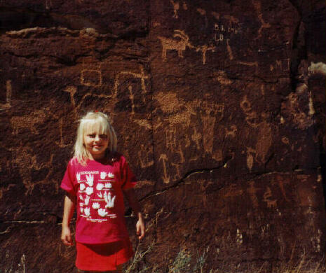
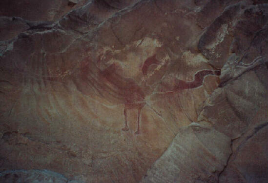
Black Dragon Canyon is very popular with rock art enthusiasts. The panel receives its name from a pictograph, which resembles a flying dragon. Pictographs and petroglyphs are spread out along the base of the high canyon walls. Unfortunately, the site has been seriously damage by inconsiderate visitors. DO NOT outline pictographs with chalk for photographing. 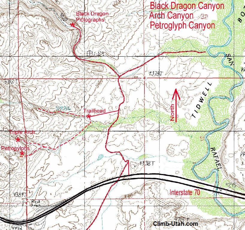 Location: Black Dragon Canyon is located just north of
I-70 near the San Rafael River. From Green River Utah go west on I-70 for 12 1/2
miles. 50-feet west of mile marker 147 is a graded county road on the north side of
I-70, there is no sign. If you are eastbound on I-70, the is an underpass 2 miles
east at mile marker 149 that you can use to safely turn around. Go through the gate
and follow the graded road north for 0.7 miles. There is a track on the west (left)
which leads to the start of the Pictograph Canyon hike. Continue on the main road
for 0.3 miles to the fork in the road. The left (west) fork leads to Black Dragon
Canyon. The right fork leads to the San Rafael River. The Famous Black Dragon
Panel (GPS Coordinates N38 56' 29", W110 25' 27") is located 0.6 miles up the
left fork on the north (right) side of the canyon, behind a log BLM fence. The last
1/2 mile of track before the panel is occasionally washed out, which means an easy hike is
required. Location: Black Dragon Canyon is located just north of
I-70 near the San Rafael River. From Green River Utah go west on I-70 for 12 1/2
miles. 50-feet west of mile marker 147 is a graded county road on the north side of
I-70, there is no sign. If you are eastbound on I-70, the is an underpass 2 miles
east at mile marker 149 that you can use to safely turn around. Go through the gate
and follow the graded road north for 0.7 miles. There is a track on the west (left)
which leads to the start of the Pictograph Canyon hike. Continue on the main road
for 0.3 miles to the fork in the road. The left (west) fork leads to Black Dragon
Canyon. The right fork leads to the San Rafael River. The Famous Black Dragon
Panel (GPS Coordinates N38 56' 29", W110 25' 27") is located 0.6 miles up the
left fork on the north (right) side of the canyon, behind a log BLM fence. The last
1/2 mile of track before the panel is occasionally washed out, which means an easy hike is
required.
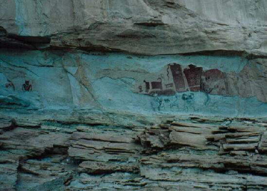
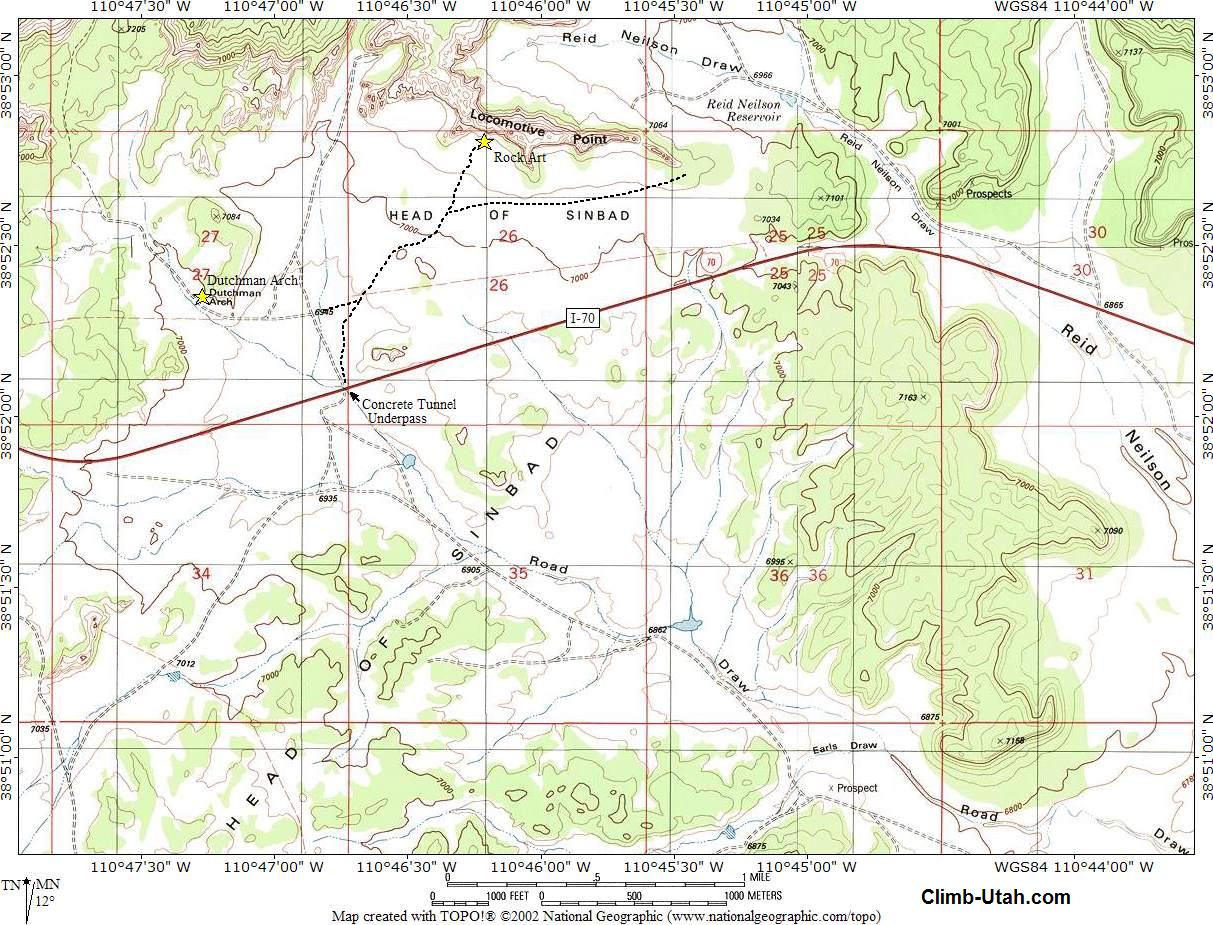
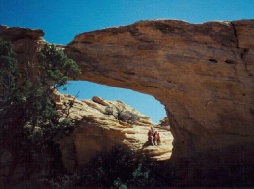
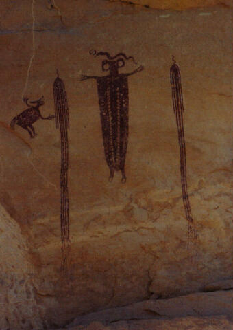
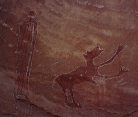
This area contains two pictograph panels often referred to as "Head of Sinbad". You will also want to visit "Dutchman Arch" if you are in the area. The pictographs are in very good condition and have not been vandalized. Dutchman Arch was named after a Dutchman who worked cattle in the area.
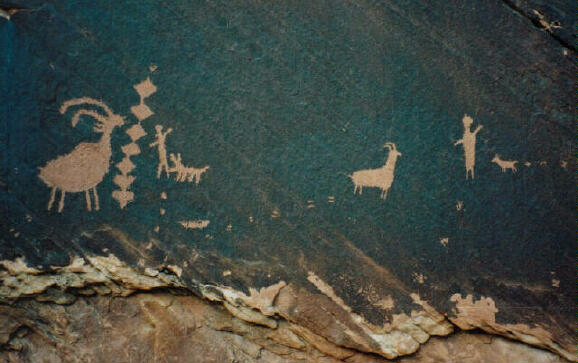
Take I-70 to Exit 131 (mile marker 131). From the cattle guard on the south side of the underpass, follow the graded dirt road signed U24/Goblin Valley/Temple Mountain, for 3.9 miles. Take the right (west) fork for 1.0 mile to a tee. Turn right (west) and travel 1.7 miles to a fork. Take the right (north) fork for 2.3 miles to the concrete underpass under I-70 and a BLM sign. The BLM sign is located at a major road junction of the San Rafael Swell known as the "Head of Sinbad". From the BLM sign, you must travel north, under I-70 using the concrete underpass. On the North side of I-70 the dirt road forks. The left fork leads to Dutchman's Arch, which is approximately 3/4 mile from the underpass. To reach the arch follow the left fork for 1/4 mile until you reach an intersection. Turn Left (west) at the intersection and follow the road to Dutchman Arch (GPS Coordinates N38 52' 21", W110 47' 17"). The arch is easy to find and sits 50' to the right of the dirt road. From the concrete underpass The right fork leads to the center of a long rock butte known as "Locomotive Point" which is approximately 1 1/2 miles from the underpass. To reach the Head of Sinbad pictographs follow the right fork for 1/4 mile until you reach a tee. Turn right (east) at the tee and follow the main road. The panels are located near the center, on the south side of Locomotive Point (GPS Coordinates N38 52' 48", W110 46' 13"). There are two Barrier Style pictograph panels enclosed inside a log BLM fence.
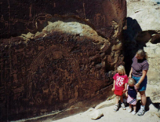
This site contains a very impressive collection of petroglyphs on a rock point overlooking the Muddy River. This is an excellent 1/2 mile hike for seniors and children. Navigation along a semi-maintained trail is easy. Location: From the town of Emery travel 3 1/2 miles north on highway 10. Take the turnoff for the town of Moore. Drive east for 0.6 miles to the signed turnoff to "Rochester Rock Art Panel". Follow the well-maintained gravel road south for 4 miles to a large parking area. The trail begins on the east side of the parking area. Follow the trail down the east side of the hill. The trail soon turns south and climbs to a ridge overlooking the Muddy River. The main petroglyph panel (GPS Coordinates N38 54' 10", W111 11' 53") is on the rocky point and faces east. There are many smaller panels in the area if you explore the rocks.
The following rock art sites are in or near the San Rafael Swell. Each of these sites is impressive enough to require an entire web page. Horseshoe Canyon is a detached unit of Canyonlands National Park. This canyon requires a half-day round trip hike to what many consider the finest pictograph site in the world. All other pictograph sites are compared to the rock art found in this canyon. Nine Mile Canyon is often referred to as the worlds longest art gallery. Nine Mile Canyon is located north of the San Rafael Swell and is a must visit for every rock art enthusiast. The canyon is 40 miles long, vehicle accessible and requires a full day to visit. Sego Canyon contains three magnificent rock art panels and a ghost town. The rock art is from three different Native American cultures. The pictograph and petroglyph panels in Sego Canyon are some of the finest vehicle accessible rock art in the San Rafael Swell and will require 2 or 3 hours to visit. [ Homepage ] [ Introduction ] [ Warning ] [ Ratings ] [ Ethics ] [ Feedback ] [ Updates ] © Copyright 2000-, Climb-Utah.com |

 Petroglyph
Canyon contains two rock art panels. The first panel is very faded and scared with
gringogylphs. The second panel is very spectacular, small, easy to find and
undamaged. This hike also visits a triple arch located in Arch Canyon. This is
an excellent hike for seniors and children. Navigation along hiker made trails is
easy and there are no hills to climb.
Petroglyph
Canyon contains two rock art panels. The first panel is very faded and scared with
gringogylphs. The second panel is very spectacular, small, easy to find and
undamaged. This hike also visits a triple arch located in Arch Canyon. This is
an excellent hike for seniors and children. Navigation along hiker made trails is
easy and there are no hills to climb.