|
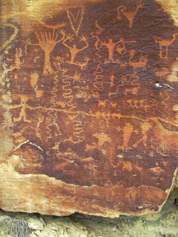
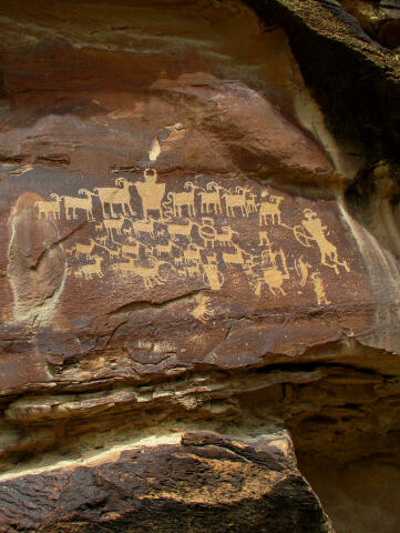
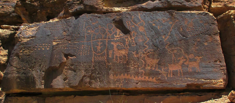
Nine Mile Canyon Guide and Information Some of the most spectacular rock art in Utah is to be found in Nine Mile Canyon northeast of Price. The canyon is actually 40 miles long, do not let the name deceive you. Nine Mile Canyon is remote, hostile, unblemished and roughly beautiful. Called "the world's longest art gallery" it is home to numerous rock art panels, including the famous "Hunter Panel". Most of the rock art was created by the Fremont Indians who occupied this area some 1,000 years ago.
Overview:
Nine Mile Canyon provides many opportunities for mountain bikes. All routes are very easy on well maintained gravel and dirt roads. With a car spot it is very easy to ride the entire canyon down hill. If you begin at the Nine Mile Canyon Day Use Area the trip is a very enjoyable 20 mile ride. A second option is to drive the main canyon and ride the side canyons.
John Wesley Powell led a government expedition through Utah in 1869. He had a topographer with him by the name of F. M. Bishop. Bishop did a nine-mile triangulation drawing, which he named Nine Mile Creek. The canyon was subsequently called Nine Mile Canyon even thought the canyon is actually 40-miles long. Maps presented to Congress by the Powell expedition clearly have Nine Mile Creek and Bishop Ridge labeled.
The Native Americans who made Nine Mile Canyon home as early as 300 A.D. are part of a civilization in Utah known as the Fremont Culture. The Fremont are a distinct and unique prehistoric culture that once inhabited the western Colorado Plateau and the eastern Great Basin. "Fremont" is actually a catch-all term used to describe scattered groups of hunters and farmers as diverse as the landscapes they inhabited. By 750 A.D., village life had developed in the heart of the Fremont region, with a number of farming villages consisting of semi-subterranean timber and mud pithouses and above-ground granaries. Fremont farming techniques appear to have been as sophisticated as those of other contemporary farming societies, involving water diversion techniques such as irrigation. Due to generally favorable climatic conditions and a culminating indigenous knowledge of the area, the era between roughly 700 A.D. and 1250 A.D. was the height of Fremont culture. Between 1250 and 1500 A.D., the Fremont culture vanished. The exact reasons for this disappearance are not known. More aggressive Ute, Paiute and Shoshoni peoples, are believed to have migrated into the region around this time, and may have displaced the Fremont or absorbed the Fremont into their own culture. Whatever the case for the Fremont demise, it is clear that these resourceful and impressive ancients had great knowledge of the land that they inhabited.
In the early development of the Uintah Basin of Utah, no road was more important than the Price-Myton road which runs through Nine Mile and Gate Canyons. The road was carved through the rugged canyon by the all-black 9th Cavalry. Nine Mile Road construction coincided with the building of Fort Duchesne on the Uintah frontier in 1886. The road was needed to supply the 300 soldiers garrisoned at Fort Duchesne. Following Indian trails, the road linked the fort with the nearest railhead in Price. For the next quarter-century, the road was the most heavily traveled in eastern Utah. It was the main route for stagecoach, mail, freight and telegraph into Uintah Basin. It was a six-day journey by wagon from Price to Fort Duchesne. Nine Mile Canyon from Price: The main access route is eight miles east of Price, on Highway 6/191, turning north on 2200 East (Soldier Creek Road), at the Chevron gas station. There is a Back Country Byway sign and information kiosk on the corner, which contains information on Nine Mile Canyon. The Information Guide begins at the kiosk. Nine Mile Canyon from Myton: From Myton travel west 1.6 miles on Highway 40. Exit on the first paved road to your left and go 0.3 miles. You will reach a Back Country Byway sign and information kiosk; you are on the historic trail headed for Nine Mile Canyon. After leaving the kiosk, travel 1.4 miles to a historic monument. Take the paved road to the right of the monument. Nine Mile Canyon is 37 miles from the monument. You will enter Nine Mile Canyon at the information guides running mileage of (38.7).
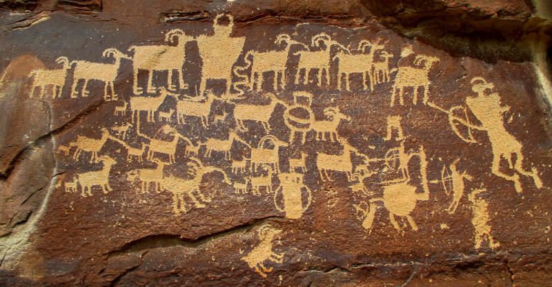
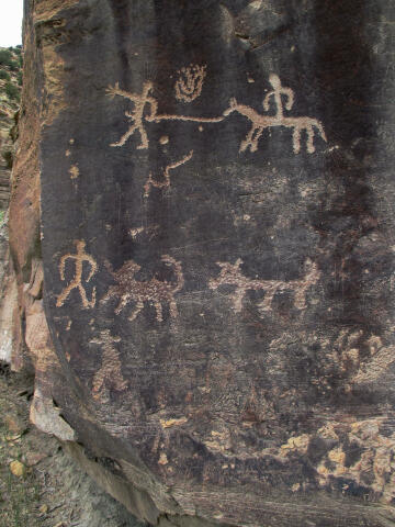
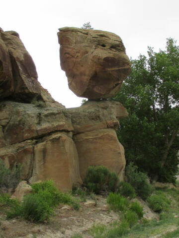
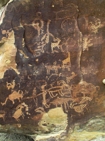
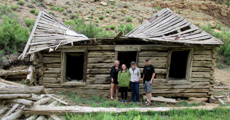
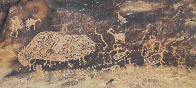
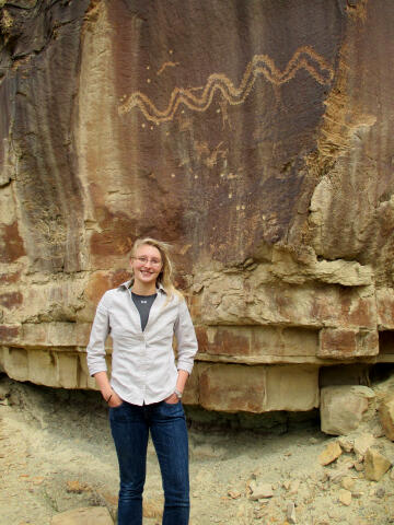
Nine Mile Canyon Guide The guide begins at the Nine Mile Canyon kiosk in Wellington, Utah. You will need to practice your math if you are joining the tour from Myton. The mileage between points of interest is shown in bold. A running total of mileage is shown in brackets. Binoculars to view the rock art and ruins high on the canyon walls are highly recommended. I suggest you bring paper, pencil and calculator to help keep track of mileage between sites, you will find these items invaluable. There are no signs in the canyon directing you to the sites; you must find them on your own with the help of this guide. A GPS is a luxury and is not required to locate any of the listed sites. All points of interest have GPS coordinates which eliminates nearly all the work required in locating the site. A GPS makes this guide the most accurate guide available for visiting Nine Mile Canyon. All waypoints and maps for Nine Mile Canyon use the WGS84 datum. 0.0 (0.0) Nine-Mile Canyon turn-off (Soldier Creek Road). Turn north. (NM01 N39° 32' 35", W110° 41' 18") 12.7 (12.7) Soldier Canyon Coal Mine. (NM02 N39° 42' 09", W110° 36' 42") 8.9 (21.6) Bridge over Minnie Maude creek. (NM03 N39° 46' 31", W110° 30' 36") 1.6 (23.2) Old Homestead. The old homestead will be on the north (left) side of the road. At one time this was a functioning ranch. (NM05 N39° 46' 34", W110° 28' 52")0.8 (24.0) Nine Mile Ranch located on the south (right) side of the road has a Bunk 'n Breakfast, Camping, Showers, Country Store and Guided Tours of rock art in the Canyon. (NM06 N39° 46' 32", W110° 27' 57") 2.6 (26.6) First major panels of petroglyphs. There is a wooden fence on the north (left) side of the road at a rocky point. The first panel is a good opportunity to view some petroglyphs up close. Exit your car and enter the wooden barrier, look carefully along the smooth base of the rock point. If you are not familiar with petroglyphs it will take your eyes a moment to become accustomed to looking for them. Some petroglyphs are distinct and others quite faint. Now stand back from the rock and look over your head. You'll see an excellent panel of petroglyphs just above a narrow ledge. (NM07 N39° 46' 48", W110° 25' 28") 1.1 (27.7) Nine Mile Canyon day use area contains restrooms and picnic area. (NM08 N39° 47' 13", W110° 24' 39") 3.2 (30.9) Ghost town of Harper, The log buildings you see are what is left of the sage coach stop, inn, post office and school. The town was first known as "Lee Station" and was a stagecoach stop. Two large barns were constructed to house the outgoing and incoming stage teams. The town spread about one-mile down the canyon. (NM09 N39° 48' 02", W110° 22' 0") 0.3 (31.2) Petroglyphs located on the north (left) side of the road at road level. The site contains a man leading a horse and rider, several anthromorphs and a horse and rider. (NM10 N39° 48' 04", W110° 21' 50") 0.6 (31.8) Sign to Argyle Canyon which enters on the north (left). (NM11 N39° 48' 13", W110° 21' 11") 0.7 (32.5) Pig Head Rock, the road curves around a balanced rock near the north (left) edge of the road. If you use your imagination, the rock can look like the cartoon character Porky Pig. The earlier freighters referred to the rock as "Pig Head Rock" since Warner Brothers had not yet created old Porky Pig. Stop 20 yards past Pig Head Rock. To the left of the road just above the car is an excellent panel with a variety of figures. Examine the rocks on both sides of the main panel for more rock art. (NM12 N39° 48' 02", W110° 20' 32") 1.3 (33.8) Sign to Harmon Canyon which enters on the south (right). Opposite the sign is a rock ledge which continues for the next 100 yards and is covered with petroglyphs. Look carefully at the smooth sections of rock covered with black patina about halfway up the hill. There are carvings all along this section. In particular, note the excellent panel with some unusual figures - human shapes with headdresses and some with toes and fingers, lines of deer, and some designs with squares created from dots. Binoculars will give you a better view of the petroglyphs, or you can climb up to the panels. (NM13 N39° 48' 28", W110° 19' 52") As you drive the remaining canyon from here watch carefully, particularly in the black patina on the rock faces. You can spot many petroglyphs. 1.3 (35.1) Owl Panel, park in the parking lot and follow the signed trail 150-yards north to the Owl Pictograph Panel. There is additional rock art along the wall in both directions. (NM13.5 N39° 49' 03", W110° 18' 45") 0.2 (35.3) Stop next to a line of tall cottonwood trees. To your north (left), look halfway up the hillside at the smooth black rock faces. A design of a large snake stands out very clearly. With your binoculars, examine the rock face to the right, it is covered with many figures quite different from those you have seen so far. There are trees, birds, and human figures with distinct hands and feet. There is an emerging use trail to the large snake if you want a closer look, the entire wall around the snake is covered in rock art. (NM14 N39° 48' 59", W110° 18' 34") 2.6 (37.9) Pass a large Cottonwood Tree on the north (left) side of the road and stop when a group of Cottonwood Trees are located 60 yards in front of you. On the north side of the road is a low ridge, 100 feet high, that nearly touches the road. On top of the ridge is a Fremont Indian site containing a pithouse and watch tower. Directly across the river, on the south side of the canyon, is a watch tower and pithouse that is located on the first level of the ridge. (NM15 N39° 48' 32", W110° 15' 44") 0.3 (38.2) Nutter's Ranch, The ranch site was first known as "Brock's" and was a stop for the first stagecoach. Freighters camped near the ranch, resting their teams before attempting the climb up Gate Canyon. Pete Francis bought the place from Brock and developed it commercially. The stop offered a fifteen room hotel, destroyed by fire in the 1930's, and a saloon, housed in the old cabin next to the road on the south. Pete Francis was shot and killed in the saloon. Preston Nutter purchased the property from Francis's widow in 1902. The house was used as the headquarters of Nutter's cattle empire, which had over 25,000 head. The hotel was used as a bunkhouse and the saloon was closed The ranch was also used as a relay station for the telegraph between Fort Duchesne and Price between 1886 and 1907. The stone building against the cliff was part of the telegraph relay system. The log cabin next to it housed the soldiers and telegraphers assigned to the telegraph relay system. The Nutter Ranch is currently owned by Hunt Oil (NM16 N39° 48' 31", W110° 15' 26"). 0.3 (38.5) Gate Canyon enters on north (left). This is the road to Myton, Utah. Remember this turn off, on our return we will explore Gate Canyon. This is an alternate route if you are returning to Salt Lake City. (NM17 N39° 48' 43", W110° 15' 06") 0.3 (38.8) There is a pull-out 15 feet past the cattle guard. There are several petroglyph panels just before the cattle guard. This site contains a centipede, elk and many other figures. (NM18 N39° 48' 38", W110° 14' 48") 2.3 (41.1) Stand on the south (right) side of the road after crossing the cattle guard. sight down the road to the east and than look 30 degrees to your left. At this point look directly up the cliff face 300 feet. A large and well preserved granary is located in a recessed area in the cliff face. The granary is well camouflaged, look for the light tan colored stone. Look directly across the river to see the remains of a watch tower on top of the first cliff level. (NM19 N39° 47' 46", W110° 12' 47") 0.6 (41.7) You are in the correct spot if a four wheel drive track running in a canyon bottom joins the main road from the north (left). Look directly ahead of you up the road to the high cliff face. You'll see a long horizontal slit in the rock. Look slightly below this and to the right. Locate the hole in some light-colored rock. The granary can be seen with binoculars in the crevice. Recently "view tubes" were installed at this location which makes locating the granary much easier. (NM20 N39° 47' 33", W110° 12' 22") 0.1 (41.8) Prickly Pear Canyon enters on the south (right). (NM21 N39° 47' 32", W110° 12' 18") 2.2 (44.0) Dry Canyon enters from the south (right). Remember this turn off, on our return we will explore Dry Canyon. If you look to your right across the canyon, you will see a strange rock formation known as "The Mummy". (NM22 N39° 47' 07", W110° 10' 09") 0.0 (44.0) Rassmussuen's Cave (large alcove) located on the north (left) is the location of some excellent pictographs (figures painted onto the cliff wall). There is a large rock in Rassmussuen's Cave which contains 5 well worn areas where corn was ground. (NM23 N39° 47' 10", W110° 10' 07") 0.1 (44.1) Daddy Canyon located on the north (left) contains restroom and corral. There are many petroglyph panels along the walls on both the east and west side of this canyon. (NM24 N39° 47' 08", W110° 10' 00") 1.0 (45.1) Cottonwood Canyon Road. The paved road turns and heads up Cottonwood Canyon at this point, The dirt road to the east (left) continues down Lower Nine Mile Canyon. Remember this turn off, on our return we will explore Lower Nine Mile Canyon. For now continue following the paved road. (NM25 N39° 47' 01", W110° 09' 03" 0.4 (45.5) On the ridge you have just driven around is the remains of a Fremont village. You can easily walk up the hillside on a hiker made trail to the west and see the rocks that outline where several pit houses once stood. Other structures were built around the large boulders. Your average tourist will be disappointed in this site as it really just contains large rocks in a square. To the north across the canyon is a long greenish ledge. With binoculars you can see it is lined with structures. (CC01 N39° 47' 03", W110° 08' 13") 0.2 (45.7) Big Buffalo Panel is the largest buffalo petroglyph to be found in the area and in located across the canyon on the east wall, just follow the well defined trail. Also look for a trail that leads north and you will find additional rock art including the pregnant buffalo panel. (CC02 N39° 46' 59", W110° 08' 04") 0.2 (45.9) Hunter Panel contains a parking area and kiosk. Follow the trail to the large rock outcropping on the west side of the canyon to locate the famous hunting scene. This is one of the finest petroglyph panels that I have ever encountered and should not be missed. (CC03 N39° 46' 48", W110° 08' 07") 0.2 (46.1) Petroglyphs on the west (right). (CC04 N39° 46' 39", W110° 08' 07") Lower Nine Mile Canyon 0.0 (0.0) Start your mileage from the Cottonwood Canyon/Nine Mile Canyon road fork. Travel east down Nine Mile Canyon. (NM25 N39° 47' 01", W110° 09' 03") 2.4 (2.4) Petroglyph panel located on the north (left) is of men, women, a turkey, a scorpion, a bird and abstract sketches. (NM27 N39° 47' 16", W110° 06' 59) 2.3 (4.7) I'm leaving this location in the guide as a historical reference, but it is my understanding the well preserved granary is on private property and is no longer accessible. Watch carefully for a little dirt road turning off to the north (left). Take this turn and go around the outcropping of rock near the right-hand side of this little road. The cliff face becomes a smooth half circle. Stop the car and look carefully about a third of the way up the cliff face. You'll see a well-preserved granary perched on a small ledge. (NM28 N39° 47' 59", W110° 05' 04") Dry Canyon0.0 (0.0) Start your mileage from the point where Dry Canyon leaves the Nine Mile Canyon road. Travel up Dry Canyon. (NM22 N39° 47' 07", W110° 10' 09") 1.9 (1.9) Excellent petroglyph panel located on the west (right) side of the road on the rock point. The panel can be easily seen from the road and contains a variety of figures. (DC01 N39° 45' 37", W110° 10' 18") Gate Canyon0.0 (0.0) Start your mileage from the point where Gate Canyon leaves the Nine Mile Canyon road. Travel up Gate Canyon. (NM17 N39° 48' 43", W110° 15' 06") 0.9 (0.9) "Outlaw Point" is the sharp bend in the road where a group of outlaws intended to ambush the soldiers escorting the army payroll and Indian annuities. The plan was to kill all 20 soldiers in the escort and leave no living witness. While some members of the "Wild Bunch" allegedly participated in the scheme, Butch Cassidy, Sundance Kid and Elza Lay did not. They knew the army would hunt them relentlessly for such a bloodbath. The army was told of the plan by an informant and the guard was double to 40 soldiers. The Outlaws hiding on the ledges hastily called off the ambush as the heavy escort rode through. There is speculation that Butch Cassidy was the informant when he realized that he would be blamed for the crime, whether he participated or not. (GC01 N39° 49' 20", W110° 14' 52") 0.4 (1.3) Stretching across the road, a stone arch once spanned the ravine at this point. It was destroyed about 1905. Some people, the stage company in particular, were afraid of the arch someday falling and killing people. Newt Stewart was hired to destroy the arch. Gate canyon receives it's name from the arch, which resembled the entrance or gate to a western ranch. (GC02 N39° 49' 37", W110° 14' 54") 1.1 (2.4) Look down into the canyon and you will see evidence of the original army built road. Notice where the road crosses the wash is "slickrock". It was common for heavily laden wagon wheels to break at this point. This presented a real problem since the nearest blacksmith shop was four miles away. To remedy this situation a forge, anvil, hammer and tongs were left at the site. At the base of the cliff notice the names painted with black axle grease. A small rock building near the names housed the forge. (GC03 N39° 50' 04", W110° 15' 11")
© Copyright 2000-, Climb-Utah.com |