[ Homepage
] [ Introduction ] [ Warning ] [ Ratings
] [ Ethics ] [ Feedback ] [ Updates
]
 |
Misery Canyon
AKA: Fat Man's Misery
Zion National Park
Technical Canyoneering
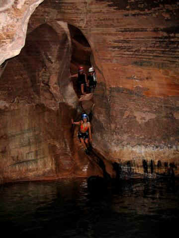
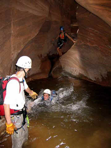
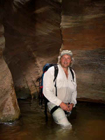
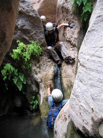
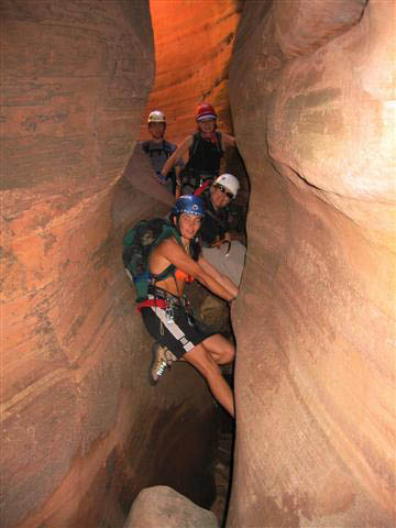
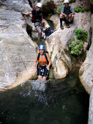
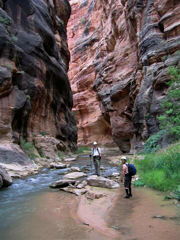
Misery Canyon is a great technical adventure. There are
several popular routes into the canyon to stop you from getting bored. All routes circle
around behind Checkerboard Mesa and descend Misery Canyon to Parunuweap
Canyon (East Fork of the Virgin River).
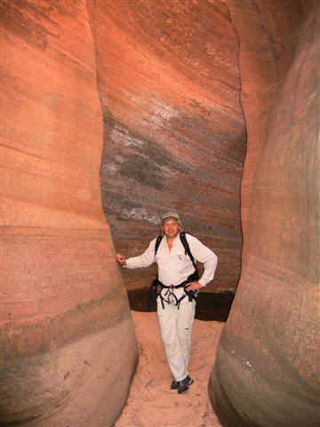
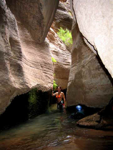
All routes contain outstanding scenery. There are several spectacular sections of narrows
and slots. The canyon is enjoyable with several short rappels, scrambling, downclimbing
and plenty of swimming and wading. |
Circle of Friends:
Misery
Canyon is part of the "Circle of Friends"
program. Members of the "Circle of Friends"
have access to more specific information, explicit route information, GPS waypoints,
trailhead location and detailed maps. If
you would like more information on joining the "Circle of
Friends" visit the sign up page.
"Circle of Friends"
General Information:
Misery
Canyon has several popular technical routes and all are presented in detail to members of
the Circle of Friends. Misery Canyon is rated 3B III using the Canyon Rating System and
requires complete technical gear. Navigation for Misery is
moderately difficult. A GPS is very useful. Good map reading skills are essential.
A
Zion Backcountry Permit is not required
since the technical section of Misery Canyon is located outside the National Park
Boundary. However, the Park will issue you a permit if you ask for one. The Park feels
that this offers you a degree of safety and provides them with the knowledge of who is
using the canyon. Misery Canyon has a moderate flashflood
danger.
Hiking Notes:
Route
information is provided of anyone wanting to visit Parunuweap
Canyon and the bottom section of Misery Canyon without using technical gear. This
route is suitable for experienced hikers only and is not a candidate for beginners or
those in poor physical condition.
Trailhead:
Information
is provided for all of the trailheads that allow access to Misery Canyon.
Powell Plaque Inscription Reads:
"Major John Wesley
Powell 1834-1902 explorer, scientist, Steven V. Jones 1840-1920 teacher, topographer,
Joseph W. Young 1829-1873 Mormon pioneer leader, Descended Labyrinth Falls 1/2 mile below
Monday, September 30, 1872 during first Parunuweap Canyon traverse. Powell named this
canyon from the Paiute Indian word 'Parunuweap' which means roaring water canyon.
Dedicated September 30, 1972."
History:
John Wesley Powell first
visited and documented Parunuweap in September 1870 during early exploration. Powell named
the canyon "Parunuweap", a Paiute term that translates as "Roaring Water
Canyon". The following excerpts are from Powell's journal.
September 10 -- The Indian name of the canyon is Paru'nuweap, or Roaring Water
Canyon. Between the little river and the foot of the walls is a dense growth of willows,
vines, and wild rosebushes, and with great difficulty we make our way through this tangled
mass. It is not a wide stream-- only 20 or 30 feet across in most places; shallow, but
very swift. After spending some hours in breaking our way through the mass of vegetation
and climbing rocks here and there, it is determined to wade along the stream. In some
places this is an easy task, but here and there we come to deep holes where we have to
wade to our armpits. Soon we come to places so narrow that the river fills the channel and
we wade perforce. In many places the bottom is a quicksand, into which we sink, and it is
with great difficulty that we make progress. In some places the holes are so deep that we
have to swim, and our little bundles of blankets and rations are fixed to a raft made of
driftwood and pushed before us. Now and then there is a little flood-plain, on which we
can walk, and we cross and recross the stream and wade along the channel where the water
is so swift as almost to carry us off our feet and were are in danger every moment of
being swept down, until night comes on. Finding a little patch of flood-plain, on which
there is a huge pile of driftwood and a clump of box-elders, and near by a mammoth stream
bursting from the rocks, we soon have a huge fire. Our clothes are spread to dry; we make
a cup of coffee, take out our bread and cheese and dried beef, and enjoy a hearty supper.
We estimate that we have traveled eight miles to-day.
The canyon here is about 1,200 feet
deep. It has been very narrow and winding all the way down to this point.
September 11 --
Wading again this morning; sinking in the quicksand, swimming the deep waters, and making
slow and painful progress where the waters are swift and the bed of the stream rocky.
The canyon is steadily becoming
deeper and in many places very narrow-- only 20 or 30 feet wide below, and in some places
no wider, and even narrower, for hundreds of feet overhead. There are places where the
river in sweeping by curves has cut far under the rocks, but still preserves its narrow
channel, so that there is an overhanging wall on one side and an inclined wall on the
other. In places a few hundred feet above, it becomes vertical again, and thus the view to
the sky is entirely closed. Everywhere this deep passage is dark and gloomy and resounds
with the noise of rapid waters. At noon we are in a canyon 2,500 feet deep, and we come to
a fall where the walls are broken down and huge rocks beset the channel, on which we
obtain a foothold to reach a level 200 feet below. Here the canyon is again wider, and we
find a flood-plain along which we can walk, now on this, now on that side of the stream.
Gradually the canyon widens; steep rapids, cascades, and cataracts are found along the
river, but we wade only where it is necessary to cross. We make progress with very great
labor, having to climb over piles of broken rocks.
 |
 |
[ Homepage
] [ Introduction ] [ Warning ] [ Ratings
] [ Ethics ] [ Feedback ] [ Updates
]
© Copyright
2000-, Climb-Utah.com |