 Frary Peak
is one of the easier Salt Lake area summits to bag. The hike to the summit can be
completed in 4 to 5 hours round trip. The trail gains 2050 feet of elevation in 3 1/2
miles. All hikers in your party should carry a minimum of two liters of water. There is
almost no shade to be found along this route. Spring and fall are the preferred seasons to
hike this summit, warm winter days can also be nice. This is a hiking trail only, no dogs or horses are allowed on the trail. Frary Peak
is one of the easier Salt Lake area summits to bag. The hike to the summit can be
completed in 4 to 5 hours round trip. The trail gains 2050 feet of elevation in 3 1/2
miles. All hikers in your party should carry a minimum of two liters of water. There is
almost no shade to be found along this route. Spring and fall are the preferred seasons to
hike this summit, warm winter days can also be nice. This is a hiking trail only, no dogs or horses are allowed on the trail.
The route contains no real obstacles. Hikers of all abilities should have little problem with this route. The Frary Peak hike is rated 2 III using the Yosemite Decimal System. Navigation for this route is easy. A GPS is a waste of time but I'll still supply the waypoints for the electronic junkies. The USGS 7.5' Map titled "Antelope Island" is helpful. All waypoints and maps for this route use the WGS84 datum.
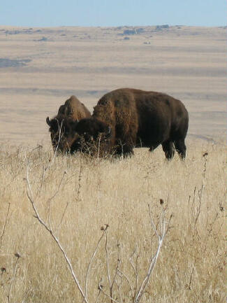
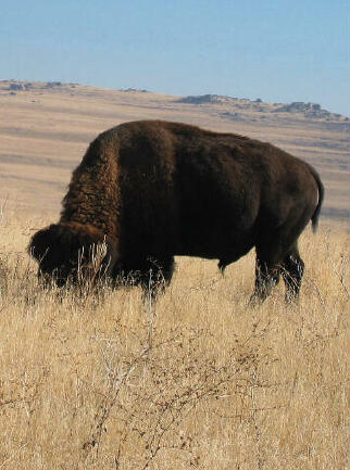
John C. Fremont and Kit Carson made the first known, non-Native American, journey to Antelope Island in 1843. They observed several antelope on the island, thus giving Antelope Island its name. Fielding Garr established a permanent residency on Antelope Island in 1848. He not only tended his own herds, but those of other stockmen as well. In 1849, Brigham Young asked Garr to manage the LDS Church's Tithing Herd, which was kept on the island until 1871. The Tithing Herd was utilized by the Perpetual Emigration Fund, which was established to help needy Mormon converts immigrate to Utah. Recipients would reimburse the fund when circumstances would allow them to do so. Reimbursement often was made in the form of livestock, which was considered better than cash. During this time, the LDS Church also invested thousands of dollars in valuable stallions and brood mares, which were turned loose on the island. Captain Howard Stansbury used Antelope Island as a base camp for a government-funded survey of the Great Salt Lake during the years of 1849-50. During the 1870s, several private homesteads were established on the island. The George Isaac Frary family stayed longer on the Island than any other homesteaders. The family moved to the desert island about 1891. George only cultivated about 16 of his 160 acres, as he preferred sailing to farming. Alice Frary, George's wife, was a schoolteacher. In September 1897, Alice became very ill. George went to Ogden for medicine, but on the midnight return trip, his small boat capsized in a strong wind and he lost the medicine. He held onto his capsized craft and by morning he had made it to the beach. Alice Frary died that afternoon. Alice requested to be buried on her island home. In 1990, the Syracuse Historical Commission placed a monument near Alice Frary's Gravesite. On February 15, 1893, twelve head of bison were transported to Antelope Island. George Frary and John Dolly loaded the bison into a sailboat and nearly capsized as they sailed the bison to Antelope Island. The Island Improvement Company owned most of the island from 1884 through 1972. Cattle and sheep were the company's primary ranching commodity, although buffalo and horses were always kept on the island. In the 1930s, Antelope Island was the largest private sheep sheering operation west of the Mississippi River. Recognizing the recreation potential of Antelope Island, the north 2,000 acres were acquired for a state park in 1969. In 1981, the state was able to acquire the rest of the island, thus preserving Antelope Island as a state park.
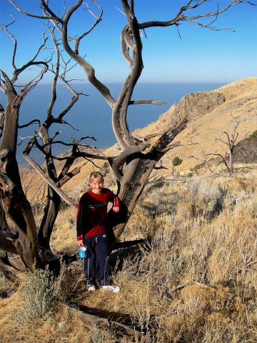
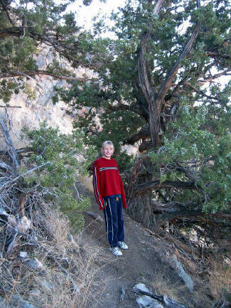
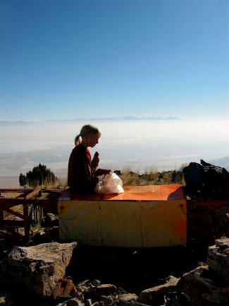
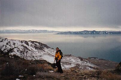
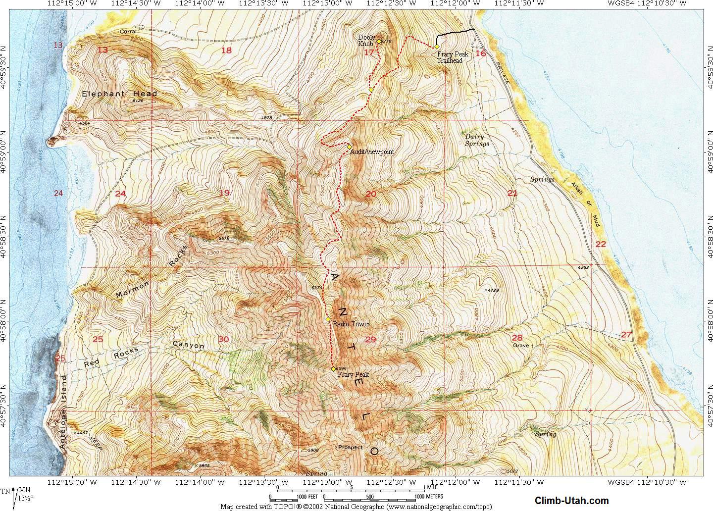
To reach Antelope Island head to Syracuse, Utah. Take I-15 to exit 332 (Antelope Drive). Follow the Antelope Island signs and travel west on Antelope Drive for 6.7 miles to the Antelope State Park entrance gate. There is a fee of $8.00 per car (current as of 2005) to enter the park. During the off-season you will need correct change at the entrance station. After paying your entrance fee drive 6.5 miles across the causeway to the Island. At the west end of the causeway there is a gate. From the gate it is 0.3 miles until the road forks, take the south (left) fork signed "Visitor Center". Travel this road for 0.6 miles and than turn south (left) on the road signed "Ranch", which leads to the Fielding Garr Ranch. Travel this road for 5.1 miles and turn west (right) on the paved Oil Well Road signed "Frary Trailhead". Travel this road for 0.6 miles to where it ends at the signed trailhead. The trailhead contains an information kiosk but no toilets. Route Information:From the Trailhead (N40° 59' 37", W112° 12' 09") the well-maintained trail climbs steeply west for a short distance and than turns south to gain the main ridge. Shortly after gaining the main ridge and 3/4 miles after leaving the trailhead you will reach the Dooly Knob Junction (N40° 59' 22", W112° 12' 40"). Those wishing to visit Dooly Knob follow the spur trail north for 1/2 mile to the 5278' summit of Dooly Knob (N40° 59' 39", W112° 12' 36"). From the Dooly Knob Junction the Frary Peak Trail travels south and loops over to the west side of the island before climbing back to the main ridge at an old mining audit (N40° 59' 02", W112° 12' 50"). The audit is 1 1/2 miles from the trailhead an provides outstanding views of Elephant Head and White Rock. Watch carefully for bighorn sheep and buffalo along the route. From the mining audit the trail snakes back and forth over the ridge offering new views with every turn as it climbs 1 1/2 miles to a minor summit with a radio tower (N40° 58' 01", W112° 13' 00"). The trail is in excellent condition to this point but deteriorates from here to the true summit, which is still 1/2 mile away. From the radio tower the main trail drops to the west, 200-feet below the rugged ridgeline, and traverses below the rock cliffs until steeply climbing Frary Peak (N40° 57' 43", W112° 12' 58"). On a clear day the view from the summit offers one of the most outstanding 360° views available anywhere.
Optional Information: © Copyright 2000-, Shane Burrows |