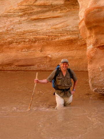
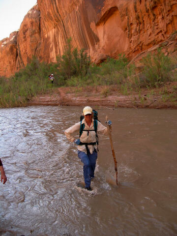
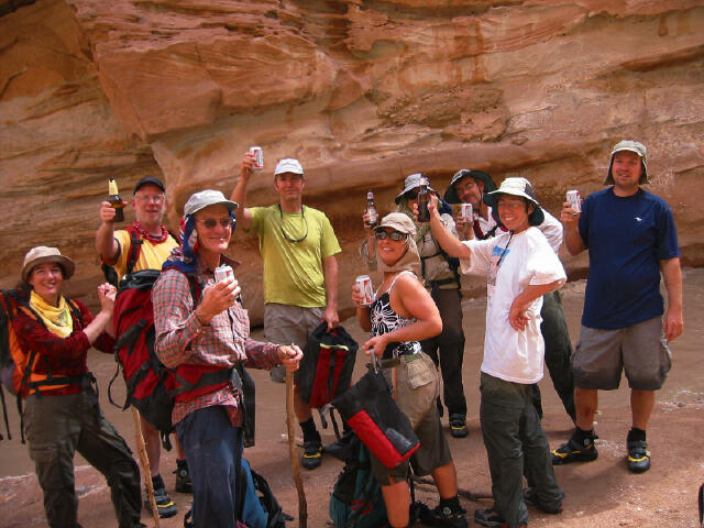
 Muddy Creek Gorge is a fun
hiking adventure suitable for all ages and abilities. The hike consists of an abundance of
ankle to knee deep wading. As with most river hikes a hiking staff or trekking poles are
an asset. Total time required for the complete hike is about 4 hours, but you can stop and
turn around anywhere you like.
Muddy Creek Gorge is a fun
hiking adventure suitable for all ages and abilities. The hike consists of an abundance of
ankle to knee deep wading. As with most river hikes a hiking staff or trekking poles are
an asset. Total time required for the complete hike is about 4 hours, but you can stop and
turn around anywhere you like.
A GPS might be helpful but is certainly not required. Navigation for this route is easy. Map reading skills and the USGS 7.5' Map titled "Hunt Draw" are recommended. I have found
the best time to hike Muddy Creek Gorge is in the early spring or fall until the end of
November. During the summer, particularly July and August, the flies along Muddy Creek can
be wicked and ruin your trip. Beginning about mid-May the gnats and no-see-ums can be very
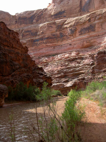
annoying. During mid summer and on through winter the creek usually runs clear. In the
spring or after a storm the creek will look like chocolate milk, which is where it
received its name. Vernon Pick, a middle-aged electrician from Minnesota, discovered the Delta Mine (Hidden Splendor) northwest of Hanksville in 1952. Vernon Pick reaped one million dollars from the mine before he sold it two years later to international financier Floyd Odlum's Atlas Corporation for $9 million and a custom-converted PBY airplane. In November 1954 Life Magazine published and 11-page article titled "Vernon Pick's $10 million Ordeal" that detailed the discovery of the Delta Mine. Publicity from this article greatly increased prospecting in the San Rafael Swell and surrounding Colorado Plateau and made the Delta Mine famous. Floyd Odlum renamed his new purchase the Hidden Splendor Mine. Odlum was certain the mine was a rich find and his geologists estimated the mine held 540,000 tons of uranium ore with an in-place value of forty dollars per ton. This would have made the mine worth nearly 22 million dollars. However, the Atlas Corporation only extracted 90,000 tons of ore from the mine before abandoning it in 1957. Local wags then dubbed the mine "Odlum's Hidden Blunder". After Atlas Corporation left several others tried unsuccessfully to extract ore. The Uranus Corporation took over the mine for a short time in cooperation with Central Oil. The Hidden Splendor Mine closed in 1957 and was eventually sold for taxes.
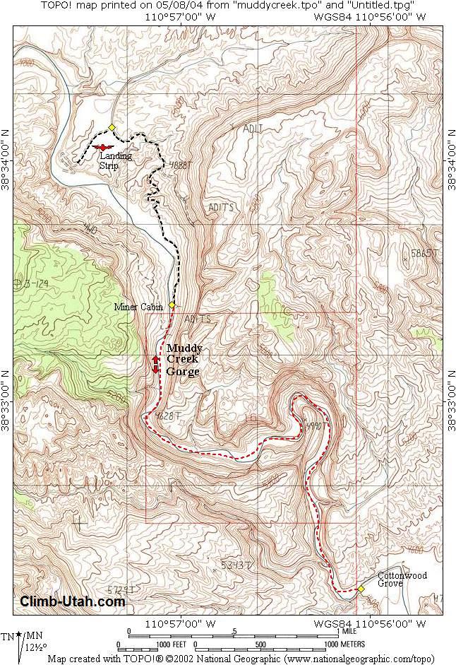
Any car during good weather can access this trailhead. The San Rafael Swell is criss-crossed with roads. Stay on the road described until told to turn off of it. From Green River, Utah follow I-70 west for 29 miles to the underpass at mile marker #131. From the cattle guard on the south side of the underpass, follow the graded dirt road signed U24/Goblin Valley/Temple Mountain, for 10.2 miles to the signed Red Canyon/Tan Seep junction. Take the right (west) fork for 3.8 miles to the signed Red Canyon/Mckay Flat junction. Turn right (west) and follow the road for 0.9 miles to the signed Mckay Flat junction. Take the left (South) fork for 8.6 miles to the signed Hidden Splendor Mine junction. At the Hidden Splendor Mine junction take the left (South) fork and follow it for 10.2 miles to the Hidden Splendor Airstrip (N38° 34' 08", W110° 57' 22"). The airstrip is identified by an information kiosk. Near the airstrip is a great place to camp with spectacular views of the Muddy River Gorge. Do not park or camp on the airstrip. The Hidden Splendor Airstrip is an official aircraft landing strip operated by the BLM and the Utah Backcountry Pilots association. Aircraft may be encountered at any time. Any interference with aircraft or aircraft operations is a federal crime.
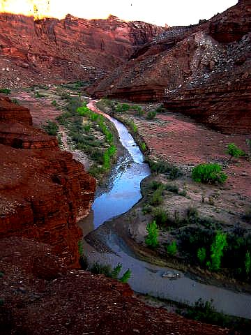
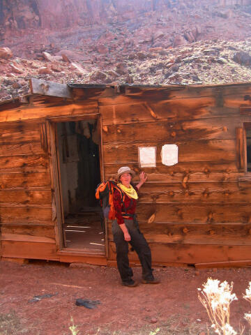
From the trailhead located at the Hidden Splendor Airstrip (N38° 34' 07", W110° 57' 25") follow the mining track south as it descends into the Muddy Creek Gorge. Just as the mining track reaches the bottom of the canyon you will encounter an old Miners Cabin (N38° 33' 24", W110° 57' 03"). Some smart-alic's refer to this old bunkhouse as the Motel 6. From the Miners Cabin, hike down stream and enjoy the numerous stream crossings, as the canyon grows narrower. The gooseneck can be very pretty and photogenic. There are several places to play along the trek. Just downstream from the gooseneck you might notice a canyon known as Knotted Rope entering from the east. Just downstream from Knotted Rope you might observe a canyon known as "The Squeeze" entering from the west. If you desire, you can explore up both these canyons for a short distance until stopped by a dryfall and plunge pool. 2 3/4 miles downstream from the Miner's Cabin, Muddy Creek finally escapes the Southern Reef and it bursts into open desert near a nice stand of cottonwood tress (N38° 32' 13", W110° 56' 03"). Enjoy the views from outside the reef and return the way you came.
© Copyright 2000-, Climb-Utah.com |