[ Homepage ] [ Introduction ] [ Warning ] [ Ratings ] [ Ethics ] [ Feedback ] [ Updates ]
  The
Little Wild Horse Canyon/Bell Canyon loop hike is 8 miles round trip and will take about 4
hours to complete. Little Wild Horse Canyon (LWH) is the better of the two canyons,
so if you can only do part of the hike do Little Wild Horse. This is a desert
environment so carry plenty of drinking water. There is nothing extremely difficult
on this hike; there is some navigation required since there is no developed or signed
trail. All obstacles can be easily bypassed if you spend a moment and look for a way
around them. The
Little Wild Horse Canyon/Bell Canyon loop hike is 8 miles round trip and will take about 4
hours to complete. Little Wild Horse Canyon (LWH) is the better of the two canyons,
so if you can only do part of the hike do Little Wild Horse. This is a desert
environment so carry plenty of drinking water. There is nothing extremely difficult
on this hike; there is some navigation required since there is no developed or signed
trail. All obstacles can be easily bypassed if you spend a moment and look for a way
around them.
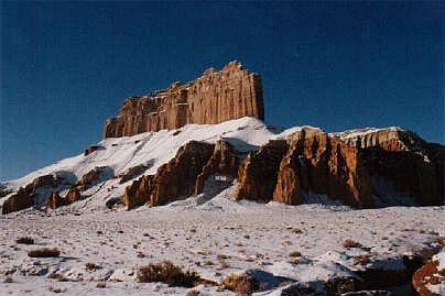
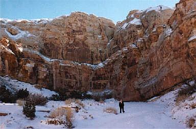
Improved campgrounds with modern toilets and hot showers are located nearby in Goblin Valley State Park. The canyons can be hiked year round except when thunderstorms are possible. Spring and Fall are the preferred hiking seasons. Hiking during the summer can be very hot and hiking during the winter can be very interesting. These canyons have a serious flash flood potential and extreme caution should be used. Occasionally there is water in some of the narrows so wear shoes that you can wade in. I hiked this canyon immediately following a major rainstorm and never encountered water over knee deep. A GPS is useful in identifying the correct trailhead and checking that you are on course. Navigation for this route is easy. Good map reading skills and the USGS 7.5' Map titled "Little Wild Horse Mesa" are essential. All waypoints and maps for this route use the WGS84 datum. This route is rated 1A II using the Canyon Rating System. CLICK HERE if your interested in hiking Little Wild Horse Canyon in winter, after a flashflood and a major snowstorm. The following is a description of what we encountered on our hike through a winter wonderland. CLICK HERE if you want to read a first hand account of being caught in a flash flood in Little Wild Horse Canyon.
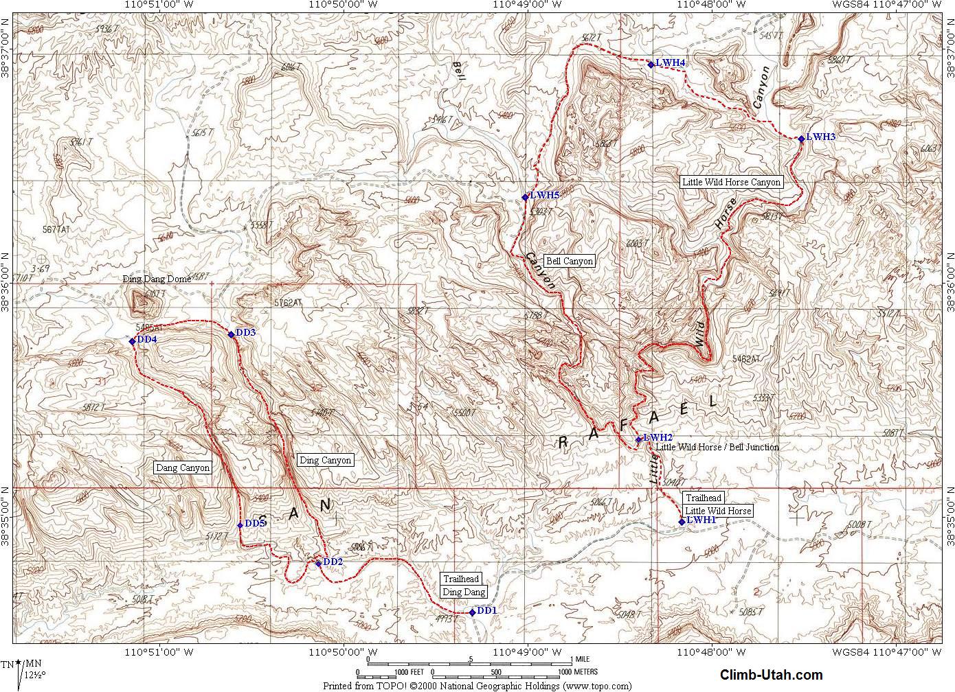
Little Wild Horse Canyon is located in Emery County between the towns of Green River and Hanksville. From Green River, Utah follow I-70 west for 11 miles to Exit #149 and Highway 24. Follow Highway 24 south for 24 miles to mile maker 136 and the signed turn-off to Goblin Valley State Park. Follow the signs to Goblin Valley State Park. The signed turn-off to Little Wild Horse Canyon is located 11 miles from Highway 24 and 2 miles before the Goblin Valley State Park fee station on the west side of the road. Follow the dirt road for 5.3 miles to the Little Wild Horse trailhead. The trailhead has parking, a vault toilet, trail register and information kiosk. The trailhead can usually be reached by passenger car in good weather.
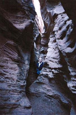
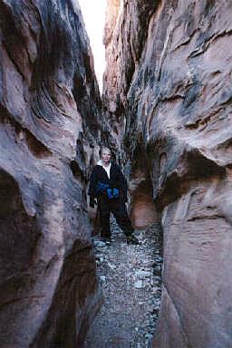
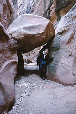
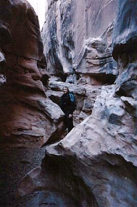
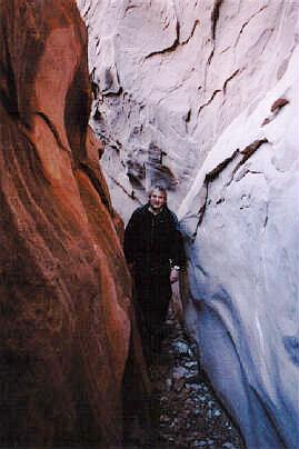
The trail can be hiked in both directions. The route described here is up Little Wild Horse and down Bell Canyon. Little Wild Horse is the better of the two canyons and many people return down Little Wild Horse instead of completing the loop. I prefer the loop since the scenery is always changing. From the Little Wild Horse Trailhead (N38° 34' 59", W110° 48' 10") hike north up the wash for 1/2-mile (15 minutes). You will encounter a small dryfall, which can be easily bypassed on the left (LUC). 150 yards past the dryfall the canyons splits (N38° 35' 20", W110° 48' 24"); straight-ahead is Bell Canyon (northwest), turn right (northeast) for Little Wild Horse Canyon. The entrance to Little Wild Horse is the most difficult navigation required and is easily missed. Little Wild Horse is a narrow slot on the right side as you are looking up canyon. Often you will find a cairn at this intersection and/or footprints branching to the right. From the moment, you enter Little Wild Horse you are in fantastic narrows. Everyone will enjoy the first long stretch of extremely tight narrows as it twists and turns through the reef. There is the possibility of water in a few places in the narrows if it has rained recently, but usually you won't have any trouble getting through with dry shoes. There is no permanent water in either of the canyons, and rainwater drains out quickly. At the head of Little Wild Horse Canyon, you will encounter the most difficult obstacle in the hike. A small 6' dryfall which can be easily climbed by the athletic. Everyone else will use the less spectacular; but equally effective method of a boost from the rear and a helping hand to get over the dryfall. Just past the top of the dryfall (N38° 36' 37", W110° 47' 31") follow a hiker made trail to the west between the main reef on the south and a small butte on the north. You will intersect a 4-wheel drive track (N38° 36' 56", W110° 48' 20"). This track runs completely across the head of Little Wild Horse Canyon so it is hard to get lost. Follow the 4-wheel drive track west to Bell Canyon. The track will climb a slight rise and than descend into Bell Canyon. As you begin to descend into Bell Canyon you will notice and old and picturesque cabin to the west across the canyon which was part of the Cistern Mine. When the 4-wheel drive track reaches the bottom of Bell Canyon (N38° 36' 22", W110° 49' 01") begin heading down canyon. The 4-wheel drive track climbs out the west side of the canyon and leads to the cabin you noticed earlier. Bell Canyon looks similar to Little Wild Horse but is only half as long and the narrows are not as tight or impressive. Just follow the canyon downstream and you will find yourself back at the trailhead.
If you use a GPS when hiking, the following coordinates eliminate all navigation difficulties associated with this hike. Name Latitude
Longitude
Description Video: Winter Hiking - Little Wild Horse Canyon Flash Flood - Little Wild Horse Canyon [ Homepage ] [ Introduction ] [ Warning ] [ Ratings ] [ Ethics ] [ Feedback ] [ Updates ] © Copyright 2000-, Climb-Utah.com |