 Hog Spring is a fun hike to a beautiful waterfall and
plunge pool. This canyon is easily accessible year round. During warm weather bring your
swimming trucks and lunch to enjoy a slice of paradise. Hog Spring is rated
1A I using the Canyon Rating.
Hog Spring is a fun hike to a beautiful waterfall and
plunge pool. This canyon is easily accessible year round. During warm weather bring your
swimming trucks and lunch to enjoy a slice of paradise. Hog Spring is rated
1A I using the Canyon Rating.
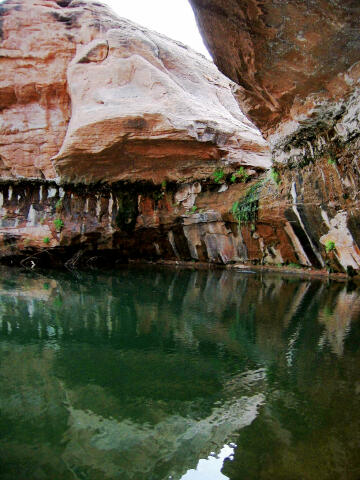
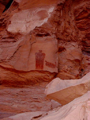
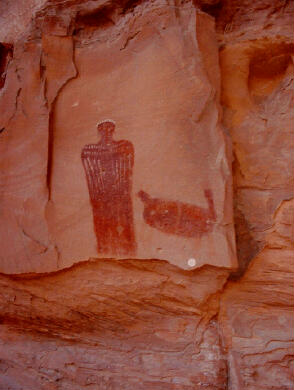
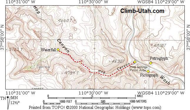
Total hiking time required form trailhead to waterfall is 30 minutes. The waterfall is approximately one mile up canyon and has an easy to follow hiker made trail all the way to the waterfall. This route is easily accessible to most adults, children and senior citizens. Expect to spend about half a day in the area if you wish to enjoy everything the area has to offer. While the spring feeding the swimming hole is perennial, occasionally during hot dry years the swimming hole will not see enough new water flow late in the summer to remain pristine. Navigation for this route is easy, just follow the stream up canyon. A GPS is not required for this hike but will help you locate the Native American rock art. The USGS 7.5' Maps titled "Black Table" and "Hite, North" show Hog Canyon.
From the Utah town of Hanksville drive south on highway 95 for 33 miles to mile marker 33.1. This is the trailhead. The trailhead is marked with a large paved pull-out, covered picnic tables, garbage bin, informative signs, restrooms and a charming suspended bridge over the river. Route Information: From the trailhead (N37° 57' 46", W110° 29' 29"), cross the river on the suspended bridge and follow the hiker made trail west as it follows the stream up Hog Canyon. Just keep following the stream and in about 30 minutes you will reach a beautiful waterfall and plunge pool (N37° 57' 53", W110° 30' 27"). The waterfall is formed where the stream flows through the Kayenta sandstone layer. If the weather is hot feel free to take a refreshing drip in the deep, clear pool. It is possible for ambitious hikers to climb around the waterfall on the south side and explore further up canyon. Rock Art Information: The second panel containing a few small, faded and vandalized petroglyphs (N37° 57' 45", W110° 29' 17") is located across the highway from the large alcove noted above. © Copyright 2000-, Climb-Utah.com |