[ Homepage
] [ Introduction ] [ Warning ] [ Ratings
] [ Ethics ] [ Feedback ] [ Updates
]
 |
Corona Arch
Moab Area
Hiking
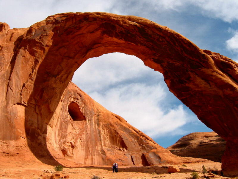
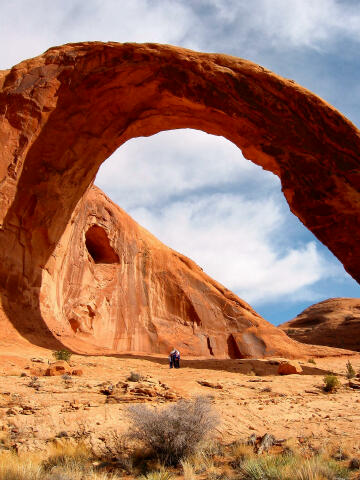
Corona
Arch is a partly freestanding arch with a 110-foot by 110-foot opening. The route is a 1
1/2 mile hike up Bootlegger Canyon. The arch is located in a striking slickrock setting.
Corona Arch is often called "Little Rainbow Bridge", which is an injustice
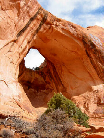
because there is nothing little about this arch. Bowtie Arch is adjacent to Corona Arch,
and is an additional attraction along the trail. This is one of the best arches in the
Moab area. |
General Information:
  The Corona Arch Trail is not
difficult and can be completed by any healthy adult or child. No special gear is required
other than footwear suitable for walking over slickrock. The hike involves walking
approximately 1 1/2 miles each way over a well maintained trail with an elevation gain of
440 feet. The route will require approximately two or three hours round trip to complete.
The Corona Arch Trail is not
difficult and can be completed by any healthy adult or child. No special gear is required
other than footwear suitable for walking over slickrock. The hike involves walking
approximately 1 1/2 miles each way over a well maintained trail with an elevation gain of
440 feet. The route will require approximately two or three hours round trip to complete.
Much of the
route is exposed to the sun and there is little shade available. During hot weather an
early morning or evening hike is recommended. Every member of your hiking party should
carry at least one liter of water. This hike should be easily accessible year round.
Navigation
for this hike is easy. The route is well marked. A GPS is over kill but I have included
the important waypoints for the gizmo junkies. The USGS 7.5' Maps titled "Gold Bar
Canyon" and "Moab" covers this hike. You should have no problems completing
this hike using only common sense. This route is rated 2 I using the Yosemite Decimal
System or 1A I using the Canyon Rating System.
Trailhead Information:
From
Moab head north out of town on U.S. Highway 191. Cross the bridge over the Colorado River.
After crossing the bridge continue north for 1.3 miles to the signed "Potash"
road, which is State Road 279. Turn west (left) and follow State Road 279 for 10.1 miles
to the signed Corona Arch trailhead. The trailhead is located on the north (right) side of
the road. The trailhead consists of a large gravel parking lot and an information kiosk.
You might
want to stop and look at the Potash Petroglyphs and Dinosaur Tracks
on the drive to the trailhead. You pass right by them and they only require a couple of
minutes extra to enjoy.
Gold Bar
Campground is located across the road from the trailhead, next to the Colorado River. For
more information or for reservations, please call the Bureau of Land Management Moab Field
Office at (435) 259-2100.
Route
Information:
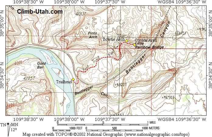
From the Corona Arch
Trailhead (N38° 34' 28", W109° 37' 57"), follow the trail as it climbs east to
a BLM register located on a small bench where you will also cross the railroad tracks.
After crossing the railroad tracks follow an old eroded road bed through a gap in the
slickrock bench above. After reaching the top of the bench the route follows a trail of
cairns (little piles of rock) northeast towards the base of a large sandstone cliff.
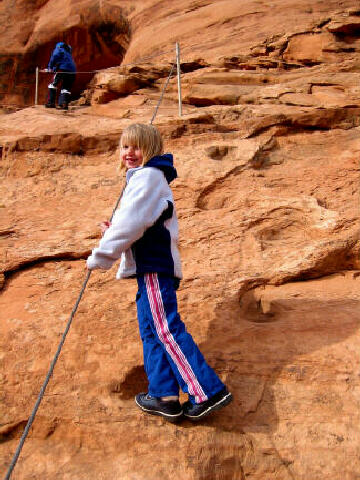
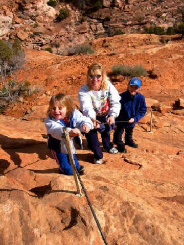
Follow the base of the cliff east to a safety cable that protects a slightly exposed
section of trail. Corona Arch is visible from this point.
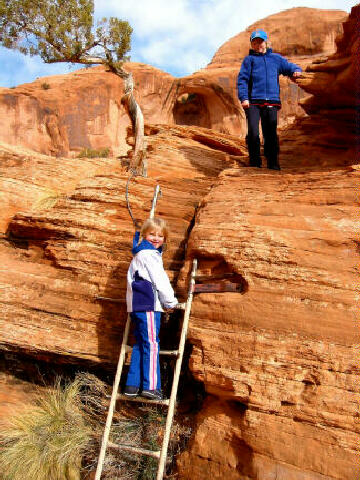
After the first safety cable,
continue to follow the base of the cliff to a second safety cable and moki steps carved
into the sandstone. Climb to the top of the moki steps. From the top of the moki steps
continue east, climb a short ladder up over a ledge and follow the cairns up to the top
of a large bench. From this point, it is easy to walk along the wide slickrock bench,
beneath Bowtie Arch (N38° 34' 28", W109° 37' 19"), and on to the base of
Corona Arch (N38° 34' 47", W109° 37' 12"). Please be careful of steep
drop-offs along the trail.
Arch Bagging Variation:
For those who would like to visit
the top of Corona Arch here is what you need to know. 50 yards east of Corona Arch is a
steep buttress that has moki steps carved into it. The steep buttress allows access to a
ledge system and the top of Corona Arch. The moki access is exposed and a fall could be
deadly. Going up the buttress is much easier then coming down. There are several pitons
and bolted anchors in the buttress that might offer some protection if you have a 60 meter
rope for belays and handlines.
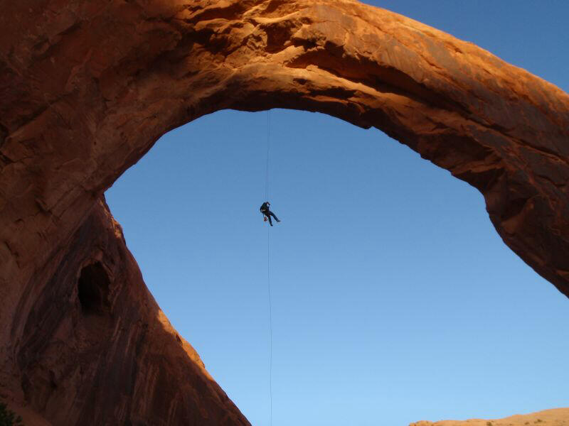
Corona Arch Rappel:
It is currently illegal
to rappel from the top of Corona Arch. In 2015 the BLM Banned all "extreme
activities" include ziplining, highlining, slacklining, climbing and
rappelling from Corona Arch. Before 2015 extreme activities from the top of
the arch were both popular and legal.
Presented for historical information only, here is the beta for rappelling
from the top of Corona Arch. The rappel required two 150-foot
ropes. The top of the arch is bolted.
The actual rappel is approximately 140-feet with the final 120-feet being
free hanging. The rappel is very intimidating and was not suitable for the faint
of heart.
Corona Arch Statistics:
Greater Arch Dimension (GAD): 110.0 feet. For this arch, the GAD is its height.
Lesser Arch Dimension (LAD): 110.0 feet. For this arch, the LAD is its span.
Arch Type: Buttress
Rock formation and/or type: Navajo Sandstone
Potash Railroad Spur:
The railroad track was built in
1964. The spur connects the Potash Plant at the end of Utah 279) to the main railroad line
in Crescent Junction. Just below Corona Arch, the train enters a one mile long tunnel to
emerge near U.S. highway 191. The train runs several times per week, hauling potash to the
main railroad line at Crescent Junction, at Interstate 70.
Video:
Enjoy a short video of Corona Arch. Video courtesy of Dan Burt.
[ Homepage
] [ Introduction ] [ Warning ] [ Ratings
] [ Ethics ] [ Feedback ] [ Updates
]
© Copyright
2000-, Climb-Utah.com |