 Sulphur Creek is a fun river
hike through a resplendent slot canyon. The hike is one of the best in Capitol Reef
National Park and is usually done in warm to hot weather. The hike involves several miles
of hiking down a river in ankle deep water with the occasional knee deep plunge pool. The
canyon contains several minor obstacles that you must scramble over. Water from the aptly
named creek is not potable so carry what you need. The route is 6 1/4 miles in length and
will require approximately 4 hours time trailhead to trailhead.
Sulphur Creek is a fun river
hike through a resplendent slot canyon. The hike is one of the best in Capitol Reef
National Park and is usually done in warm to hot weather. The hike involves several miles
of hiking down a river in ankle deep water with the occasional knee deep plunge pool. The
canyon contains several minor obstacles that you must scramble over. Water from the aptly
named creek is not potable so carry what you need. The route is 6 1/4 miles in length and
will require approximately 4 hours time trailhead to trailhead.
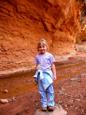
A car or bicycle shuttle is required to complete this adventure. If a shuttle is not available it is usually very easy to hitch a ride back to the Chimney Rock Trailhead. The route ends at the Capitol Reef Visitors Center so there are plenty of people to beg a ride from. A large, easy to read sign that states "Next Trailhead" makes hitching a ride much easier and faster. Sulphur Creek requires no special gear. Footwear compatible with hiking long distances in water should be worn, an old pair of running shoes are excellent. If you wish to complete this hike in cold weather than I suggest wearing a pair of neoprene socks inside your shoes to help keep your little piggy's warm. Experienced hikers will have no problem completing this route. This hike is excellent for children under competent adult supervision; the miles melt away for the kids as they splash in the water and scramble over rocks. Beware, there are three sections on this route where young children and beginning hikers might require some assistance. Teamwork is the name of the game at these places. A GPS is
useful in identifying the correct trailhead and checking that you are on course.
Navigation for this route is easy. Map reading skills and the USGS 7.5' Map titled
"Twin Rocks" are useful. Sulphur Creek can be completed in the opposite directions from what is described below. This creates an uphill hike and it's more difficult to hitch a ride back to your starting point. Important Note:
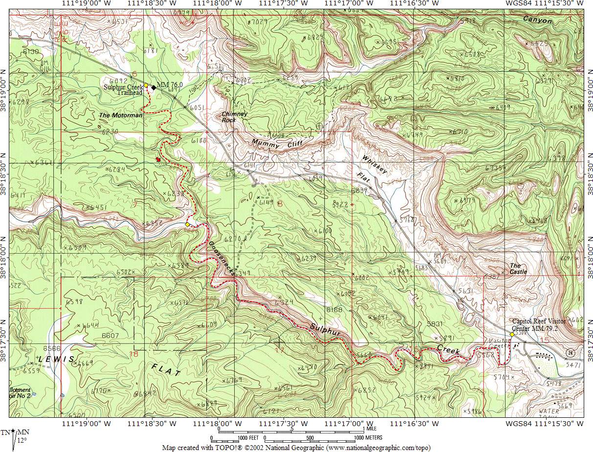
The route ends at the Capitol Reef Visitor Center and this is where you should leave a shuttle vehicle if one is available. If leaving a shuttle vehicle it is considered good manners to leave it at the south end of the parking lot. If a shuttle vehicle is not available it is usually not a problem since it is not difficult to hitch a ride back to the trailhead. A large easy to read sign stating "Chimney Rock Trailhead" makes catching a ride really simple. To reach the trailhead from the Visitor Center take Highway 24 west for 3.3 miles to the Sulpher Creek Trailhead located at mile marker 75.9 on the south side of the highway. The trailhead has parking for a dozen vehicles. Any vehicle can access this trailhead and all roads are paved.
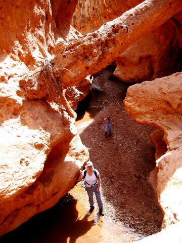
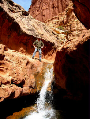
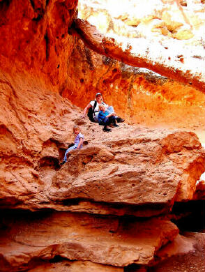
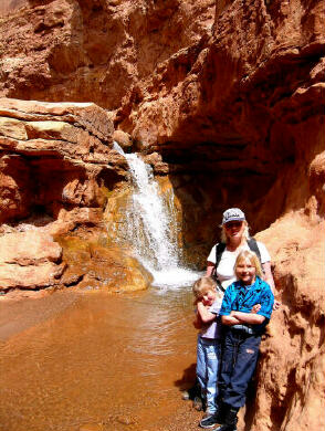
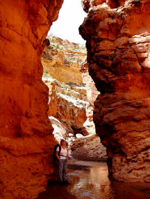
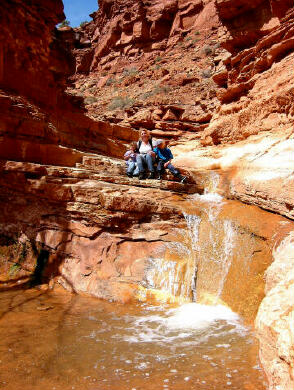
From the Sulpher Creek Trailhead (N38° 19' 02", W111° 18' 33"), follow the trail south into the bottom of the dry wash on the south side of Highway 24 and begin hiking down the dry wash. There is no trail, but navigation is quite simple, just keep heading downstream and you will eventually end up back at the Visitor Center. The gradually deepening dry wash winds 1 3/4 miles to it's confluence (N38° 18' 12", W111° 18' 14") with Sulphur Creek. If the river is knee deep or more turn around and come back anther day. The hike is probably best for children when the water is approximately ankle deep at Sulphur Creek. Once you reach the flowing water of Sulphur Creek turn downstream and follow the flowing waters into the section of canyon known as "The Goosenecks". Look up at the North Rim and you can glimpse the Gooseneck viewing platform and the less hearty tourist's 600' overhead. The first obstacle you will encounter is a dazzling 10' waterfall, which knifes into a sandstone slot. This obstacle is easily bypassed via a ledge on the south (right) side. Continue a short distance down canyon and you will encounter the second obstacle of your adventure, a second 12' waterfall that is as brilliant as the first. This waterfall is also bypassed using a ledge and chute on the south (right) side. The next mile of canyon involves plenty of wading as the water cascades over small ledges and into numerous pools forming a natural water park for kids of all ages. The best part of the hike is sandwiched between the first and third waterfall. Approximately one mile before the finish of your trek you will encounter the third and final obstacle. An enjoyable 6' waterfall into a sweet plunge pool. This obstacle can be bypassed using the ledge system on the north side of the stream or you can downclimb the short cliff on the south side. During warm weather you can also slide down this waterfall into the plunge pool, make certain you check out the landing for hidden rocks before anyone slides down. From the final waterfall to the Visitor Center the canyon begins to open up. When you reach the end of the hike at the Visitor Center (N38° 17' 32", W111° 15' 46") you must circle around the north side to reach the parking lot.
Optional
Route Information: Sunset
Point Trail - This short, signed, easy trail leads about 1/4 miles southeastward
to Sunset Point. The point lies at an elevation of 6,400 feet and overlooks Sulphur Creek.
This overlook is easy to reach and provides views of Capitol Reef and the Henry Mountains. Video:
© Copyright 2000-, Climb-Utah.com |