[ Homepage ] [ Introduction ] [ Warning ] [ Ratings ] [ Ethics ] [ Feedback ] [ Updates ]
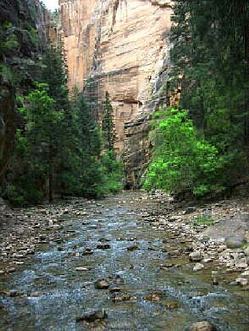
  Zion Narrows is a canyoneering adventure that will require 8 to 12 hours to complete for
experienced hikers. The less experienced, high water (above 50 cfs) or muddy water
conditions will require additional time. The total route is 16 miles long. This route is
commonly done as a two day backpack, which allows more time to explore and admire the
scenery. A car shuttle is required for this adventure. Trailhead
shuttle information is available.
Zion Narrows is a canyoneering adventure that will require 8 to 12 hours to complete for
experienced hikers. The less experienced, high water (above 50 cfs) or muddy water
conditions will require additional time. The total route is 16 miles long. This route is
commonly done as a two day backpack, which allows more time to explore and admire the
scenery. A car shuttle is required for this adventure. Trailhead
shuttle information is available.
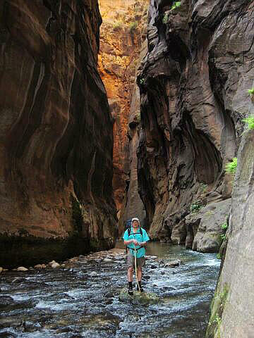
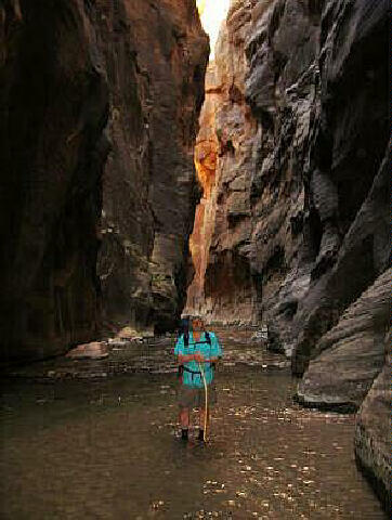
Zion Narrows is rated 1C IV using the Canyon Rating System. You will need a Zion backcountry permit for this canyon. Zion Narrows has a high flash flood danger, check the weather report at the Visitor Center when you pick up your permit. You will need a hiking staff or trekking poles to provide sure footing during the miles of river hiking. An old pair of ski poles also work great. You will want to pack everything that is to stay dry into drybags. Visit my gear suggestions for the proper footwear and clothing, this is not a technical canyon so many of the items in the gear section are not required but are still worth reading about to gather ideas for enjoyable wet canyoneering. Zion Narrows
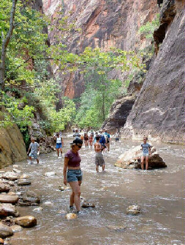
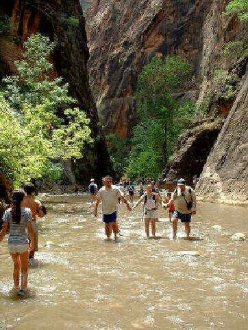
requires many miles of wading with depths up to chest deep combined with a couple of
possible short swims. If required, the swimming is never further than 10 to 15 feet. The
water is cold and a hot day is suggested. Everyone will want to carry a warm, dry fleece
to put on if they become chilled or at the canyon end so toss one into your drybag. Campsites: The following is a list of campsites and size: Campsite #1 - 4 People Human Waste Disposal: The National Park Service has introduced a human waste disposal program for overnight users in the Narrows. An environmentally friendly human waste disposal bag, complete with use and disposal instructions, will be provided to all party members with every Narrows overnight permit. The bag is called Restop 2. It is a lightweight, sanitary way to pack out waste. The bag within a bag design and ziplock closure securely contains waste and odor, while the special blend of polymers instantly breaks down waste and turns it into a deodorized gel. The contents of the bag are safe for landfills and may be deposited in the trash. Use of this waste disposal system is strongly encouraged as a means for protecting the Virgin River.
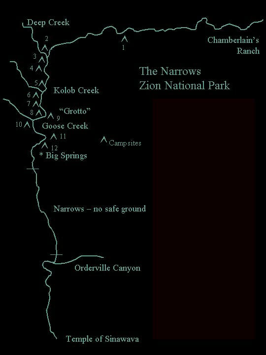
From the East Entrance of Zion National Park, drive east 2.4 miles on highway 9. Turn left (north) at the signed "North Fork" junction. Drive 18 miles north (The first 5.5 miles of road are paved) until you encounter a wooden bridge that crosses the North Fork of the Virgin River. Just beyond the bridge turn left on a smaller dirt road and follow it for 0.5 miles to a gate that allows access to Chamberlain's Ranch. Continue through the gate and follow the dirt road for an additional 0.5 miles to the trailhead. The trailhead is identified as where the road crosses the river with a sign and trail register. Please close all gates behind you and remember that you are on private property so show the proper respect. Any vehicle can be driven to the trailhead with no problems during dry conditions. This road becomes impassable to all vehicles (including four wheel drive) during wet conditions. Lower
Trailhead:
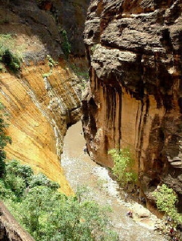
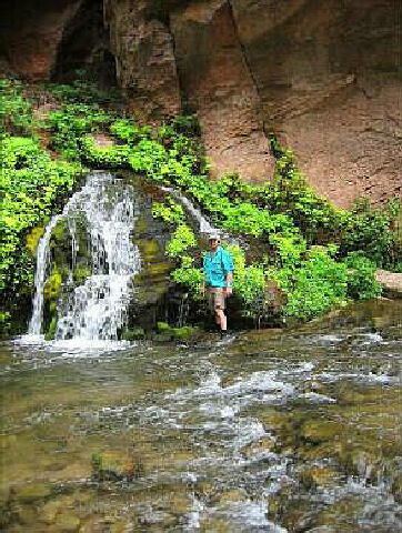
From the Upper Trailhead (N37° 23' 06", W112° 50' 20") follow the dirt road across the stream. After hiking down the road for 1 1/2 miles past irrigated pastures you will encounter the rustic Bulloch Cabin. Just keep hiking downstream and you will not get lost. The canyon will begin to slot up and 5 miles from the trailhead you will encounter Simon Gulch (N37° 22' 16", W112° 54' 45") entering on the right (LDC). 1 1/2 miles below Simon Gulch you will reach a 12-foot waterfall. The waterfall is bypassed using an obvious route to the left (LDC). 8 miles from the trailhead Deep Creek (N37° 21' 33", W112° 57' 06") joins from the right (LDC) with the North Fork and the water volume more than doubles. This is the half-way point mileage wise of your trek but not time wise. 1 1/2 miles below the Deep Creek junction the notorious Kolob Creek (N37° 20' 57", W112° 57' 03") enters on the right (LDC). Just after leaving Kolob Creek and you will have reached the half-way point time wise in your adventure. 1 1/4 miles below Kolob Creek you will meet Goose Creek (N37° 20' 18", W112° 57' 26") entering from the right (LDC). Each of these side canyons add to the water volume in the Virgin River. 3/4 miles below the Goose Creek junction you will enjoy seeing Big Springs (N37° 19' 52", W112° 57' 25") spouting from the canyon wall. There is a small amount of poison ivy in the canyon between Goose Creek and Big Springs so use caution. No camping is allowed below Big Springs. The next 2 miles to the junction with Orderville Gulch (N37° 18' 28", W112° 56' 48") is the narrowest portion of "The Narrows". At the Orderville Gulch junction you should begin meeting a flock of tourists who have hiked up canyon from the Temple of the Sinawava. It is at this point in the route where you might possibly encounter the scariest item on your adventure and that would be middle aged European men with beer guts hiking in Speedo swimming suits. Do not look directly at them or you could go blind. You have been warned. 1 1/4 miles below the junction with Orderville Gulch you will notice Mystery Falls (N37° 17' 57", W112° 56' 40") exiting from the hanging Mystery Canyon and flowing down the left side (LDC) canyon wall. At this point the flock of tourists hiking up from the bottom has now turned into a thundering herd. 1 1/4 miles below Mystery Falls you will reach the Temple of the Sinawava (N37° 17' 07", W112° 56' 52") and the shuttle bus. Ride the shuttle bus back to the Lower Trailhead and your waiting vehicle at the Zion Canyon Visitor Center.
Video:
[ Homepage ] [ Introduction ] [ Warning ] [ Ratings ] [ Ethics ] [ Feedback ] [ Updates ] © Copyright 2002-, Climb-Utah.com |