[ Homepage ] [ Introduction ] [ Warning ] [ Ratings ] [ Ethics ] [ Feedback ] [ Updates ]
  Behunin Canyon is a canyoneering adventure requiring technical gear. The canyon has very little water and a
southern exposure. This canyon is very hot and in direct sunlight during the summer;
these conditions result in an early snow melt and warm temperatures during the spring and
fall. This adventure will require 8 to 9 hours to complete. You will need two
50-meter ropes. I recommend carrying several slings, 50 feet of webbing, and several
rappel rings. A bolt kit is not required. There are plenty of natural, easily
seen anchors.
Behunin Canyon is a canyoneering adventure requiring technical gear. The canyon has very little water and a
southern exposure. This canyon is very hot and in direct sunlight during the summer;
these conditions result in an early snow melt and warm temperatures during the spring and
fall. This adventure will require 8 to 9 hours to complete. You will need two
50-meter ropes. I recommend carrying several slings, 50 feet of webbing, and several
rappel rings. A bolt kit is not required. There are plenty of natural, easily
seen anchors.
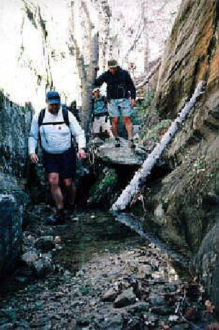
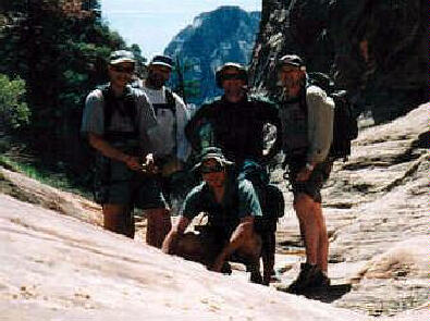
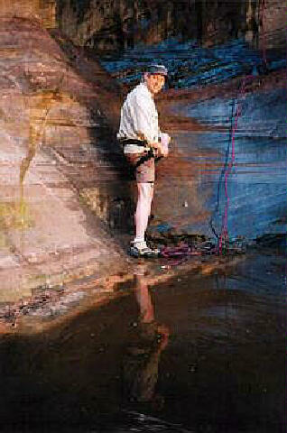
You may need to wade in ankle-to-waist deep water in several short sections. A wetsuit is not required in normal conditions. I suggest a group size of four or less. The second-to-last rappel station is very exposed and will only accommodate 4 canyoneers comfortably. Temple of Sinawava is the USGS 7.5 minute topographical map that shows Behunin Canyon. Navigation for this adventure is easy. All waypoints and maps for this route use the WGS84 datum. Once you begin descending this canyon, please stay in the watercourse and help eliminate the problem of social trails circumventing obstacles. There is no need to leave the watercourse once you begin descending this canyon. The erosion problem created by social trails is a concern to the National Park Service. The watercourse offers more fun and adventure and helps reduce the erosion problem. Please practice responsible canyoneering. Behunin Canyon is rated 3A III using the Canyon Rating System. You will need a Zion backcountry permit to enter the canyon. Behunin Canyon has a moderate flash flood danger; check the weather report at the Visitor Center when you pick up your permit.
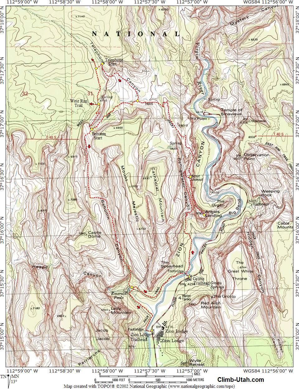
From the main Zion Canyon Visitor's Center take the Zion Canyon Shuttle to the Grotto Picnic Area located in Zion Canyon. Since this adventure is a popular early and late season trip, the shuttle might not be operating and you may need to drive to the Grotto Picnic Area. This trailhead is also the start of the very popular Angels Landing Trail.
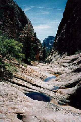
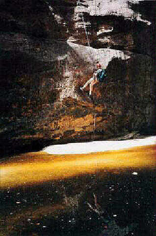
From the Grotto Picnic Area (N37° 15' 34", W112° 57' 02"), take the paved West Rim Trail towards Angels Landing. The route snakes up Refrigerator Canyon and climbs the famous Walter's Wiggles to Scout Lookout (N37° 16' 30", W112° 57' 01"). The trail divides here with the right fork leading to Angel's Landing (N37° 16' 09", W112° 56' 52") and the left fork leading to the West Rim. Visiting Angel's Landing will add 1 hour to your adventure. From Scout Lookout, continue climbing the West Rim Trail until you reach Behunin Pass (N37° 16' 57", W112° 58' 11"), which should require approximately two hours from the trailhead. The pass is very easy to identify and begins at the bottom of the switchbacks leading up to West Rim Spring. Drop into Behunin Canyon and begin bushwhacking down the drainage; there is a hiker made trail most of the route with occasional slickrock hiking. Continue down canyon until you are stopped by a dryfall and two large potholes. From here you can walk a small ledge to the left (LDC) for 100 yards until you intersect a chimney which can be easily downclimbed. Directly across the wash from the chimney bottom is a large Ponderosa pine with webbing; this is your first rappel point. This low angle rappel is 120 feet and will deposit you next to a Ponderosa pine. The second rappel is from this Ponderosa pine and is 150 feet into a really cool little bowl in the slickrock. The third rappel is from a three bolt anchor in the slickrock bowl and is 120 feet. This rappel deposits you in the canyon bottom. The next rappel comes after an enjoyable 10 minute hike down canyon. The rappel anchor is located on the bench to the right and consists of two bolts. This rappel is 80 feet and occasionally deposits you in a shallow, knee deep pool, depending on recent weather conditions. From here the route continues down canyon for 1/4 mile through a nice section of narrows. When you reach a small dryfall and pool blocking your route you could climb a hiker made trail to the right (LDC), but the real canyoneering studs stay in the watercourse and rappel 60 feet from a large log into a plunge pool. Swim 10 feet to exit the pool. Continue hiking down canyon. The canyon turns left in a series of short drops and pools. Do not climb to the pine tree on the left (LDC) with webbing, this leads to a crumbly, dirty rappel. Instead, stay in the watercourse and rappel 80 feet from a tree. The rappel leads to the edge of a pool that you circumvent and then continue the rappel into a knee-deep pool. Scramble 100 yards downstream to the beginning of the final series of three rappels. The first of the final three rappel anchors is located up and to the left (LDC) and drops 50 feet to the base of a large chokestone; sometimes this rappel is avoided by climbing over the chokestone. The ledge at the base of the chokestone is small and will only accommodate four canyoneers comfortably and no more than five people maximum. The next rappel is from the base of the chokestone and is 140 feet. This rappel deposits you on a large ledge. The final rappel anchor is located at the base of the large chokestone below and to the left of the ledge. This final rappel anchor is bolted and drops 160' to the base of the cliff above the Emerald Pools. The final rappel has a reputation for being difficult when it's time to pull your ropes. The final rappel can easily be broken into two stages by the last person down, to create an easy rope pull. The mid-stage anchor consists of 3 bolts located just above the point where the slickrock rolls over into a free rappel. Note that this requires that the canyoneer clip into the mid-stage rappel, then pull the ropes and re-rig while hanging from the bolts. If you skip the mid-stage anchors, you will find that your ropes pull easier if you back away from the cliff. Some canyoneers will tie a short rope to the end of their pull cord to allow them to get a better angle on the pull cord; others find it is easier to climb on top of the large boulder at the base of the cliff and shake their ropes loose. Bushwhack and scramble down to the Emerald Pools. Dazzle the amazed tourists with your tales of daring, and follow the signed trail back to the Grotto Picnic Area. If the Shuttle system is operating, save 10 minutes and hike down to the Zion Lodge (N37° 15' 05", W112° 57' 21") and grab a cold brew. Optional Tele-hunin
Route:
Video:
[ Homepage ] [ Introduction ] [ Warning ] [ Ratings ] [ Ethics ] [ Feedback ] [ Updates ] © Copyright 2000-, Climb-Utah.com |